
This was not my first visit to the nation's first battlefield park, though it was by far my most extensive tour of the field. Usually a trip to Fort Oglethorpe (the sleepy town that the battlefield calls home) entails a day spent whisking from site to site in the car, stopping only at particular points of interest that call for a feet-on-the-ground survey. I decided that yesterday would be different. And it was, thanks largely to this wonderful title:
This book, part of a (so far) three-title series takes the battle's actions and breaks them down chronologically and by specific section of the battlefield. Each turn of the page brings a detailed synopsis of the events in question on the left side, while the entire right page is a beautifully detailed close-up map of the described phase of the battle.
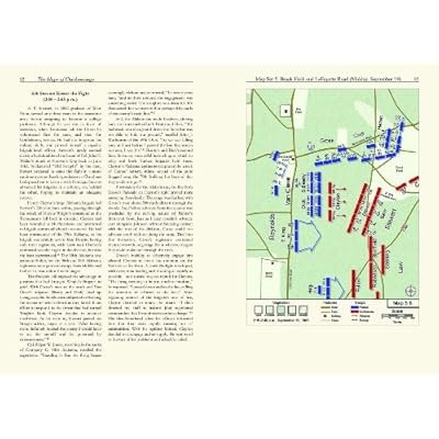
Also, in an easy-to-overlook detail, each map is of the same scale and orientation of its brethren, making it easier than ever to follow a battle. This is a simple detail, but one that - even by itself - makes this series stand out from the rest.
Armed with this book, I set out on what would be a fourteen-mile hike: From the visitor center to Alexander's Bridge Road; thence to one of the park's trails that eventually brought me down to the Brotherton Road; following that, I moved to the Brotherton Farm and south to a park trail in the vicinity of the Viniard Field action; recrossing the Lafayette Road, I moved into the brush to scout Confederate positions on the afternoon of 19 September before returning to the Lafayette Road via the Viniard-Alexander Road; moving then through the Brock Field to the Wilder monument, I then moved north over Lytle Hill and South Dyer Field before finally crossing the Vittetoe Farm and finding myself atop Horseshoe Ridge and Snodgrass Hill; from there it was an easy hike back to the Lafayette Road and thence south to Poe Field; finally I turned north one last time to follow Battleline Road around Kelly Field and back to the visitor center. The above is a combination of the park's "Historical" trail and it's "Confederate Line" trail, and was customized by myself in order to gain a thorough grasp of the battle's progression.
Without Powell's atlas, I would never have been able to stand in Winfrey Field and see Cleburne's night attack. I would not have been able to stand at the Heg monument and watch Hood's troops go into the ditch beyond and be flanked by Lilly's battery and Wilder's brigade. I can claim that with authority since yesterday marked what is probably my tenth visit to the field, and such understanding has always eluded me. The yesterday's battlefield romp has demystified what has always been a confused and chaotic affair, and I cannot recommended this indispensable title enough to any student of the battle.
More to come.
Image sources: personal collection, http://www.amazon.com
No comments:
Post a Comment